


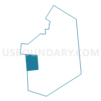
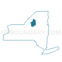
Voting District 110001, Lewis County, New York
About
Outline

Summary
| Unique Area Identifier | 629538 |
| Name | Voting District 110001 |
| County | Lewis County |
| State | New York |
| Area (square miles) | 65.34 |
| Land Area (square miles) | 65.17 |
| Water Area (square miles) | 0.16 |
| % of Land Area | 99.75 |
| % of Water Area | 0.25 |
| Latitude of the Internal Point | 43.71538860 |
| Longtitude of the Internal Point | -75.71689610 |
Maps

Graphs
Select a template below for downloading or customizing gragh for Voting District 110001, Lewis County, New York


Neighbors
Neighoring Voting District (by Name) Neighboring Voting District on the Map
- Voting District 050001, Lewis County, NY
- Voting District 100001, Lewis County, NY
- Voting District 130001, Lewis County, NY
- Voting District 140001, Lewis County, NY
- Voting District 170001, Lewis County, NY
- Voting District 170001, Oswego County, NY
- Voting District 230001, Jefferson County, NY
Top 10 Neighboring County Subdivision (by Population) Neighboring County Subdivision on the Map
- West Turin town, Lewis County, NY (1,524)
- Martinsburg town, Lewis County, NY (1,433)
- Redfield town, Oswego County, NY (550)
- Harrisburg town, Lewis County, NY (437)
- Pinckney town, Lewis County, NY (329)
- Worth town, Jefferson County, NY (231)
- Osceola town, Lewis County, NY (229)
- Montague town, Lewis County, NY (78)
Top 10 Neighboring Unified School District (by Population) Neighboring Unified School District on the Map
- Camden Central School District, NY (13,328)
- South Jefferson Central School District, NY (11,237)
- Lowville Academy and Central School District, NY (8,762)
- South Lewis Central School District, NY (6,803)
- Sandy Creek Central School District, NY (5,720)
Top 10 Neighboring State Legislative District Lower Chamber (by Population) Neighboring State Legislative District Lower Chamber on the Map
Top 10 Neighboring State Legislative District Upper Chamber (by Population) Neighboring State Legislative District Upper Chamber on the Map
Top 10 Neighboring 111th Congressional District (by Population) Neighboring 111th Congressional District on the Map
Top 10 Neighboring Census Tract (by Population) Neighboring Census Tract on the Map
- Census Tract 9507, Lewis County, NY (5,000)
- Census Tract 201, Oswego County, NY (3,543)
- Census Tract 625, Jefferson County, NY (3,494)
- Census Tract 9505, Lewis County, NY (2,474)
Top 10 Neighboring 5-Digit ZIP Code Tabulation Area (by Population) Neighboring 5-Digit ZIP Code Tabulation Area on the Map
- 13367, NY (8,830)
- 13316, NY (6,460)
- 13626, NY (2,267)
- 13325, NY (866)
- 13659, NY (593)
- 13437, NY (460)